Barry strengthening, nearing Louisiana coast
Published 7:05 am Saturday, July 13, 2019
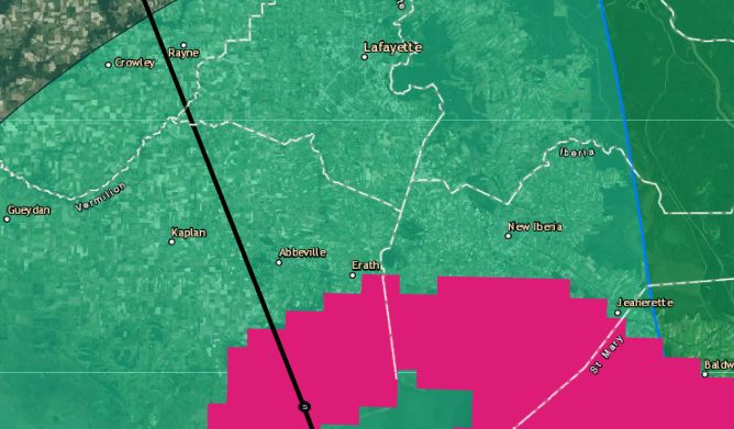
- TS Barry Saturday 4 a.m.
The latest guidance from the National Hurricane Center shows Tropical Storm Barry moving closer to the coast and strengthening as it approaches.
Trending
The National Hurricane Center’s 7 a.m. update shows Barry 50 miles west-southwest of Morgan City and 60 miles south of Lafayette. Though the storm did a little stutter step and slowed to 3 mph overnight, it is now back up to 5 mph as it nears landfall. It is also moving northwest at 305 degrees.
The storm’s central pressure has also dropped to 991 millibars. The storm is expected to make landfall as a Category 1 hurricane in the next few hours, then lose strength as it moves inland.
Tropical-storm-force winds extend outward up to 175 miles from the center of the storm, but wind shear on the northern and western quadrants have given the storm an asymmetrical shape, with most of the convection driving the system in the southern and eastern areas. A reporting station near Houma recently reported sustained winds of 53 mph.
Trending
In New Iberia, a very light misting of rain continues with light but increasing winds. Overnight sustained winds reached 23 mph, with gusts up to 33 mph.
A search and rescue command post is scheduled to be set up in the parking lot of the Lowes location on Highway 14 near U.S. Highway 90 Saturday morning.
Also, a reception station for people displaced as water rises is scheduled to be established Saturday morning at the Cyr Saint Center in City Park. Because the Teche Area is in the direct path of the storm, coupled with the propensity for flooding, shelters are not being opened in Iberia Parish. Instead, anyone needing help as a result of the storm will be transported north to a mega-shelter in Alexandria if shelter is required.
Curfews will be in effect from 10 p.m. until 6 a.m. Saturday night within the city limits of New Iberia, Jeanerette and Delcambre, as well as in St. Mary and St. Martin parishes.
According to the narrative of the forecast, Barry should begin a turn toward the north Saturday night or Sunday.
The advisory still shows Barry bringing a dangerous storm surge, heavy rains, and wind conditions across the north-central Gulf coast. The current track of the storm shows it dropping life-threatening rainfall of 15 to 20 inches — with locally higher amounts possible — over St. Mary, Iberia, and lower St. Martin parishes as it moves ashore. The latest advice predicts people will be trapped in homes in those areas due to flooding from the rains expected to drench the region during the slow-moving storm.
A storm surge of more than 3 feet is expected in coastal sections of Vermilion, Iberia, and St. Mary parishes, including Intracoastal City, Delcambre, Cypremort Point, and Burns Point.
The current forecast said damaging winds will cause scattered to numerous power outages, blow down trees, and damage homes and businesses across south central Louisiana and parts of central Louisiana.
Isolated tornadoes are possible along the path of this storm in south central and central Louisiana.
The next partial National Hurricane Center update is expected at 10 a.m.