Officials watching dual storms as preparations continue
Published 12:38 pm Sunday, August 23, 2020
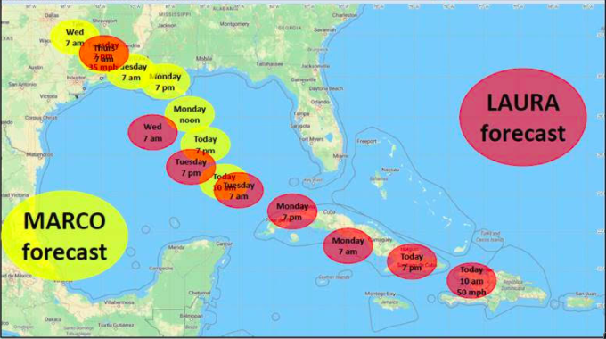
- Laura/Marco forecast track
The latest National Weather Service projection has Tropical Storm Laura hitting the Louisiana coast both stronger and farther west than initially indicated — neither of which is a good sign for the Teche Area.
In an update Sunday afternoon, Laura’s forecast has shifted west – and its growth stronger. Currently, Laura is projected to be a Category 2 hurricane at landfall in southwest Louisiana sometime late Wednesday night or early Thursday morning.
Both St. Martin and Iberia parishes have issued state of emergency declarations in advance of the two storms. The location and schedule for sandbag distributions sites are included in the links with this story.
Iberia Parish President Larry Richard released his emergency declaration late Saturday night, retroactive to 5 p.m. Friday. In the release announcing the declaration, he also announced a voluntary evacuation for all of Iberia Parish, but specifically those residents in low-lying and flood-prone areas or with special needs.
In St. Martin Parish, President Chester Cedars announced the state of emergency Friday afternoon. He also issued a voluntary evacuation for residents in the Stephensville/Belle River area of lower St. Martin Parish Sunday afternoon.
The more immediate looming weather threat, Hurricane Marco, is expected to make landfall in southeast Louisiana Monday as a Category 1 storm. Marco’s forecast shows it moving west across south central Louisiana as a tropical storm early Tuesday, before weakening to a tropical depression in southwest Louisiana and southeast Texas Tuesday afternoon and Tuesday night.
During Marco’s passage, hurricane force winds could occur from Intracoastal City eastward along the coast, with tropical storm force winds extending inland across south central Louisiana between late Monday and early Tuesday. The disturbance is expected to drive a possible storm surge in the 2 to 4 foot above ground level range along the Louisiana coast. Depending on where the rain bands form, local amounts of 2 to 4 inches are possible Tuesday.
As for Tropical Storm Laura, it is predicted to be a much more serious weather event. The NWS predicts hurricane force winds will be possible across the region starting late Wednesday and continuing Thursday. At the coast, water could be over 10 feet above ground level. Depending on where Laura makes landfall, storm surge can back up rivers and bayous and flood over 30 miles inland. Depending on where the rain bands form, 5 to 10 inches with locally 15 inches will be possible starting Wednesday into Thursday.