Laura a hurricane, heading toward Texas-Louisiana border
Published 10:57 am Tuesday, August 25, 2020
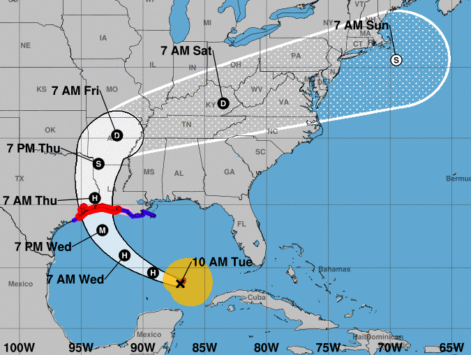
- Laura 1115 8/25/20
Satellite imagery shows that Hurricane Laura has become a little better organized since it crossed western Cuba, and it now has a central dense overcast and some outer banding in the southern quadrant
The National Hurricane Center issued an advisory at 7:15 a.m. declaring the storm a Category 1 hurricane.
Reports from Air Force Reserve and NOAA Hurricane Hunter aircraft included winds measured with a stepped frequency microwave radiometer of near 65 knots, 700-mb flight-level winds as high as 77 knots, and a central pressure near 990 mb. Based on that data, Laura was upgraded to a hurricane with an initial intensity of 65 knots.
In its 10 a.m. update, the NHC said the hurricane is currently moving west-northwest at 14 knots. The current forecast shows Laura continuing west-northwestward today followed by a turn toward the northwest tonight and toward the north by Wednesday night and Thursday.
This will result in the hurricane making landfall in the area of southwestern Louisiana or the upper Texas coast late Wednesday night or Thursday morning.
The new forecast track before landfall has been nudged a little to the west of the previous track in response to a westward nudge in the guidance. However, it still lies a little east of the consensus models at the time of landfall.
There is the danger of life-threatening storm surge accompanied by large and dangerous waves from San Luis Pass, Texas, to the mouth of the Mississippi River, including areas inside the Port Arthur Hurricane Flood Protection system. A storm surge warning is in effect and residents should follow any advice given by local officials. Actions to protect life and property should be rushed to completion today, as water levels will begin to rise Wednesday.
Hurricane conditions are expected by Wednesday evening in the area from San Luis Pass, Texas, to west of Morgan City. A hurricane warning is in effect, with tropical storm conditions
expected to begin in the warning area Wednesday afternoon.
The threat of widespread flash and urban flooding along with small streams overflowing their banks will be increasing Wednesday night into Thursday from far eastern Texas, across Louisiana, and into Arkansas. This will also lead to minor to isolated moderate river flooding. The heavy rainfall threat will spread northeastward into the middle-Mississippi, lower Ohio, and Tennessee Valleys Friday and Saturday.
Currently, the hurricane looks a little ragged, with little or no convection outside of the central dense overcast and the southern quadrant banding. This may be due to dry air in the vicinity and some light northerly shear. Conditions appear generally favorable for strengthening during the next 36 hours, and the new intensity forecast calls for Laura to become a major hurricane during this time.
The global model are in good agreement that the hurricane should encounter increasing shear in the last 12 hours before landfall, although the potential impacts on the landfall intensity are
unclear. After landfall, Laura should weaken through the 96 hour point. After that, some re-intensification is expected as the storm becomes extratropical.