Laura update paints dire picture for Teche Area
Published 7:03 pm Wednesday, August 26, 2020
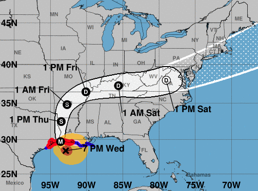
- Laura 7 pm 8/26/20
The latest update on Hurricane Laura brings sobering detail to the strength of the storm as it approaches the Louisiana coast.
In Iberia Parish, a storm surge and tropical storm warning remain in effect, as well as a hurricane watch. The peak wind forecast for the area is for 35 to 45 mph with gusts to 60 mph continuing until late Thursday morning.
The wind threat — to be ready for winds in the range from 58 to 73 mph — has remained nearly steady from the last forecast. Residents should plan for dangerous wind of equivalent strong tropical storm force. Any last minute efforts to protect life and property should now be complete. The area remains subject to significant wind damage.
Now is the time to shelter from dangerous wind.
Potential impacts from the main wind event are unfolding. They include the potential for life-threatening and historic storm surge of 8 to 12 feet above ground somewhere within surge prone areas. There is a potential for storm surge flooding greater than 9 feet above ground through Friday morning.
Residents who have not evacuated should remain sheltered in a safe location and not venture outside. If possible, residents should move to upper floors to escape rising water if necessary.
In addition to the storm surge, there is also a flash Flood watch in effect due to the potential of another 4 to 8 inches of rain, with locally higher amounts.
According to forecasters, emergency plans should include the potential for major flooding from heavy rain. Evacuations and rescues are likely.
The National Hurricane Center is advising residents to heed any flood watches and warnings. Failure to take action will likely result in serious injury or loss of life as rivers and tributaries may rapidly overflow their banks in multiple places. Small streams, creeks, canals, and ditches may become dangerous rivers. Flood control systems and barriers may become stressed.
The NHC guidance stated that flood waters can enter many structures within multiple communities, some structures becoming uninhabitable or washed away. There are also many places where flood waters may cover escape routes when streets and parking lots become rivers of moving water with underpasses submerged, making driving conditions dangerous. Many road and bridge closures are expected, with some weakened or washed out.
Laura also brings the potential for several tornadoes. The NHC guidance urges residents to stay in their shelter keeping informed of the latest tornado situation. and move quickly to the safest place within the shelter if a tornado warning is issued.
The occurrence of scattered tornadoes can also hinder the execution of emergency plans during tropical events. Several places may experience tornado damage with a few spots of considerable damage, power loss, and
communications failures. Tornadoes could leave roofs torn off frame houses, mobile homes demolished, boxcars overturned, large trees snapped or uprooted, vehicles tumbled, and small boats tossed about. Dangerous projectiles can add to the toll.
At 7 p.m., the eye of the storm was located near latitude 28.4 north, longitude 92.9 west. Laura is moving toward the north-northwest near 15 mph. A turn toward the north is expected overnight, and a northward motion should continue on Thursday. A northeastward to east-northeastward motion is expected Thursday night and Friday.
On the forecast track, Laura will approach the upper Texas and southwest Louisiana coasts this evening and move inland within that area tonight. The center of Laura is forecast to move over northwestern Louisiana tomorrow, across Arkansas Thursday night, and over the mid-Mississippi Valley on Friday.
Reports from a NOAA Hurricane Hunter aircraft indicate that the maximum sustained winds have increased to near 150 mph with higher gusts. Laura is an extremely dangerous category 4 hurricane on the Saffir-Simpson Hurricane Wind Scale.
Some additional strengthening is possible tonight before Laura reaches the northwest Gulf coast overnight. Rapid weakening is expected after Laura moves inland.
Hurricane-force winds extend outward up to 60 miles from the center and tropical-storm-force winds extend outward up to 205 miles. A sustained wind of 48 mph was recently reported at Cypremort Point.
The minimum central pressure estimated from NOAA Hurricane Hunter aircraft observations is 940 mb (27.76 inches).