OVERTIME OUTDOORS: Conundrum blues: Will the costly CPRA project $olve coastal land loss in Barataria?
Published 12:00 am Wednesday, April 3, 2024
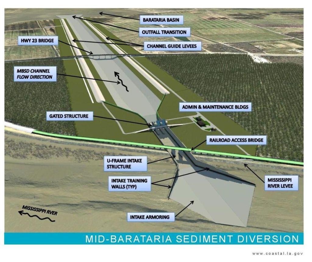
- This graphic from Louisiana's Coastal Protection and Restoration Authority shows the plans for the Mid-Barataria Sediment Diversion project in Plaquemines Parish. Many say it has grown too costly and will put commercial fishermen in the region out of work.
Fellow Louisianians to the east in Plaquemines Parish are dealing with a perplexing situation, one tied to unprecedented coastal land loss in the Mid-Barataria Basin.
There’s no question the problem must be addressed and many believe it has been with the creation of the Mid-Barataria Sediment Diversion project that has potential to restore 17,000 of wetlands in the Barataria Basin. The project’s stated goal is to re-establish a connection between the Mississippi River and the Basin.
Trending
However, Louisiana Gov. Jeff Landry has ordered the Coastal Protection and Restoration Authority to conduct a complete review of the project bearing a price tag that has mushroomed from an estimated $375 million in 2012 to $3 billion. Commercial and, even, recreational fishermen also are concerned and question the extra freshwater and sediment from the Big Muddy.
Veteran outdoors writer Bob Marshall, a Pulitzer Prize-winning Louisiana environmental journalist, addressed the issue recently in The Advocate. Marshall wrote in his column he contacted two highly regarded Ph.Ds who have studied wetlands and our coastal crisis after he attempted to seek information from CPRA and the governor’s office.
Donald Boesch, a professor of marine science, and Natalie Snider, an independent scientist with a focus on coastal ecosystems, responded to Marshall’s timely and hard-hitting questions, starting with “will this kill fishing businesses, and is that fair?”
Boesch and Snider replied there will be temporary losses, then noted some fishermen would have to relocate. However, the project includes $305 million to help them relocate and learn new ways of harvesting the same finfish.
“More importantly, the long-term visibility of fishing depends on the acres of wetlands we can maintain, and that depends on reconnecting the Mississippi River to the coast,” they said.
Marshall asked about the prospect of dredge-and-fill operations that bring in less river water and are much less expensive and the scientists said, “That’s still the largest part of the master plan. But that becomes too costly because of the need to redo these operations in about 20 years due to subsidence …”
Trending
The outdoors writer’s next question was about the price tag, which has blown up to $225,000 per acre of wetlands created. Boesch and Snider said that development was unexpected but noted much of that cost involved years of research and computer modeling to plug large holes in knowledge needed to make projections on what could be accomplished.
And, they replied, the $225,000 price tag is based on rebuilding approximately 21-25 square miles and their research shows the CPRA relied on sea level projections nearly four times higher than those used by the International Panel on Climate Change. According to the IPCC number, the projection shows twice as many wetlands by 2070, which means the $225,000 is cut in half.
Marshall brought up the point that this is the first controlled engineered diversion ever built, then asked if it was just a huge, expensive experiment, and thus too risky?
“First, we know this works because new land is still being built on the Atchafalaya River’s delta. And, for that matter, there’s land being built at a natural crevasse downriver now called Neptune Pass,” Boesch and Snider said.
They also brought up climate change, previously known as global warming, which is a hot button issue for so many people on either side of the debate, one that is oft-polarizing among political allegiances.
The bottom line is to get started and learn the best way to reconnect the river to our coast, according to Marshall. Hear hear.
DON SHOOPMAN is outdoors editor of The Daily Iberian.