TS Laura continues to track westward as it strengthens
Published 8:21 am Tuesday, August 25, 2020
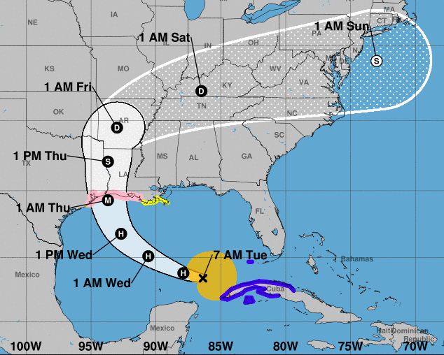
- Laura track 8/25 7 a.m.
As Tropical Storm — soon to be Hurricane — Laura hits the Gulf of Mexico’s warm waters for a couple of days after rolling the length of Cuba, the storm is predicted to continue strengthening as it moves to the northwest.
One development that bodes well for the Teche Area is that the latest forecasts show the storm’s landfall continuing to move west, lessening its wind effects on the Acadiana region.
As of 7 a.m., the center of Tropical Storm Laura was located near latitude 23.4 North, longitude 86.4 West. Laura is moving toward the west-northwest near 17 mph (28 km/h), and this
general motion should continue today. A turn toward the northwest is forecast by Wednesday, and a northwestward to north-northwestward motion should continue through Wednesday night. On the forecast track, the center of Laura will move away from Cuba and over the southeastern Gulf of Mexico this morning. Laura is then forecast to move over the central and northwestern Gulf of Mexico tonight and Wednesday, approach the Upper Texas and Southwest Louisiana coasts on Wednesday night and move inland near those areas on Thursday.
Reports from a NOAA Hurricane Hunter aircraft indicate that maximum sustained winds have increased to near 70 mph (110 km/h) with higher gusts. Significant strengthening is forecast during the next 48 hours, and Laura is expected to be a major hurricane at landfall.
Tropical-storm-force winds extend outward up to 175 miles (280 km) from the center.
The minimum central pressure estimated from the Hurricane Hunter aircraft data is 991 mb (29.26 inches).
The combination of a dangerous storm surge and the tide will cause normally dry areas near the coast to be flooded by rising waters moving inland from the shoreline. The current predictions show a storm surge of seven to 11 feet anticipated from High Island, Texas to Morgan City, including Sabine Lake, Calcasieu Lake, and Vermilion Bay. East of Morgan City to the mouth of the Mississippi River is anticipated to face four to six feet of storm surge
The deepest water will occur along the immediate coast near and to the right of the landfall location, where the surge will be accompanied by large and destructive waves. Surge-related
flooding depends on the relative timing of the surge and the tidal cycle, and can vary greatly over short distances.
Laura is expected to produce rainfall of 4 to 8 inches, with isolated maximum amounts of 12
inches across portions of the Texas and Louisiana border north into portions of the lower
Mississippi Valley. That rainfall could cause widespread flash and urban flooding, small streams to overflow their banks, and minor to isolated moderate river flooding.
Hurricane conditions are possible in the hurricane watch area along the Gulf Coast by late Wednesday, with tropical storm conditions possible by Wednesday afternoon.
The next forecast update is expected at 10 a.m.