10 a.m. UPDATE: Hurricane Ida warning area shrinks to target Louisiana
Published 9:55 am Saturday, August 28, 2021
- Hurricane Ida 082821 1000
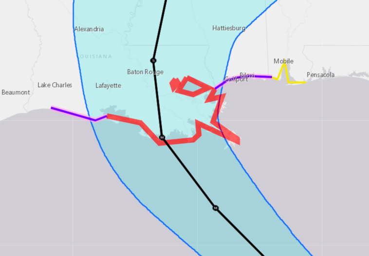
The watches and warnings for Hurricane Ida have been shifted slightly eastward as the storm continues to move to the northwest, strengthening over the warm waters of the Gulf of Mexico.
According to the National Weather Service Office in Lake Charles, Ida is expected to intensify to a category 3 or 4 hurricane today or tonight. Landfall projections still show the Morgan City region Sunday evening as a likely site for the storm to come ashore.
People in the eyewall will see the highest winds of 80 to 100 mph, causing widespread power outages, numerous trees blown down, and significant damage to homes and businesses. In addition, life-threatening storm surge will flood up to 9 feet above ground level.
The Tropical Storm Warning has been extended eastward along the northern Gulf coast to the Alabama/Florida border, while the Hurricane Watch along the coast of Mississippi from the Mouth of the Pearl River to the Mississippi/Alabama border has been discontinued. The Hurricane Watch along the coast of Louisiana west of Intracoastal City has also been discontinued.
The Storm Surge Watch from Sabine Pass to Rockefeller Wildlife Refuge has been discontinued.
At 10 a.m., the center of Hurricane Ida was located near latitude 24.8 North, longitude 86.1 West, or about 350 miles south-southeast of the mouth of the Mississippi River and 435 miles southeast of Houma.
Ida is moving toward the northwest at about 16 mph. This general motion should continue through late Sunday or early Monday, followed by a slower northward motion on Monday.
On the forecast track, the center of Ida will move over the southeastern Gulf of Mexico today and move over the central Gulf of Mexico tonight and early Sunday. Ida is then expected to make landfall along the U.S. northern Gulf coast within the hurricane warning area on Sunday, and then move inland over portions of Louisiana or western Mississippi later on Monday.
Maximum sustained winds are near 85 mph with higher gusts. Rapid strengthening is forecast during the next 24 to 36 hours and Ida is expected to be an extremely dangerous major hurricane when it approaches the northern Gulf coast on Sunday.
Weakening is expected after Ida makes landfall.
Hurricane-force winds extend outward up to 30 miles from the center and tropical-storm-force winds extend outward up to 125 miles.
The latest minimum central pressure estimated from Air Force Reserve reconnaissance aircraft data is 984 mb.