Dorian expected to hit Florida as major hurricane
Published 7:00 am Friday, August 30, 2019
- Dorian expected to hit Florida as major hurricane
Hurricane Dorian is expected to make landfall in Florida as an “extremely dangerous” Category 4 storm if it makes landfall on the eastern coast of Florida early next week as projected, the National Hurricane Center said Thursday.
That could make Dorian the strongest direct hit to Florida’s east coast since Hurricane Andrew in 1992.
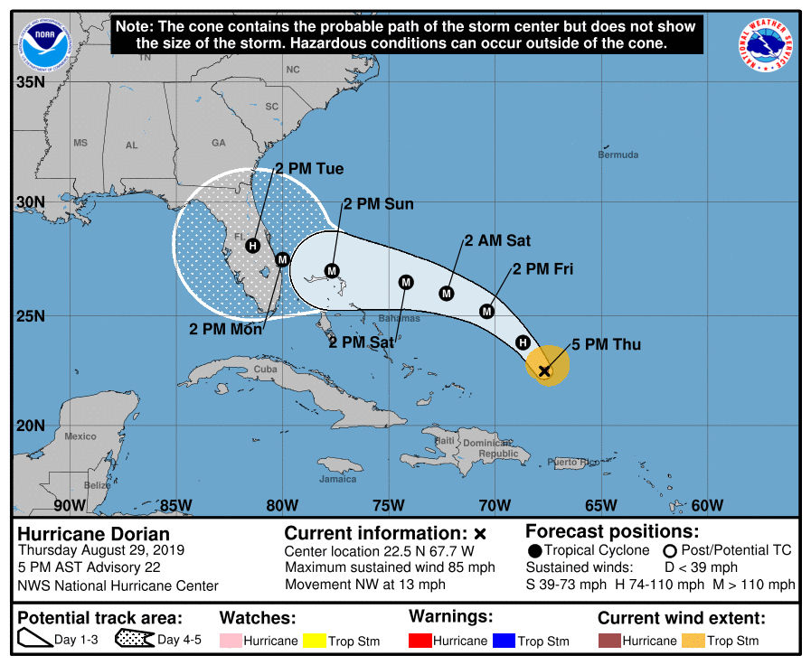
The NHC said in a prepared statement at 5 p.m. Thursday that There has been little overall change in the structure of Dorian during the day. The hurricane has several well-defined bands of convection wrapping into the center and a small central dense overcast.
At 5 p.m., Dorian remained a Category 1 storm with winds continuing at 85 mph. It was 330 miles east of the Bahamas, moving northwest at 13 mph. Projections are for the storm’s center to reach centrral Florida around 2 p.m. Tuesday and cross into the Gulf of Mexico after that, though the hurricane center’s forecast cone is uncertain the farther ahead the forecast.
No evacuations had been announced in Florida as of 5 p.m. Thursday. President Donald Trump on Thursday canceled a weekend visit to Poland to focus on the federal storm response.
Airlines have canceled 83 flights, according to FlightAware.com. Seventy-eight were canceled Thursday and five have been canceled for Friday. Florida Gov, Ron DeSantis declared a state of emergency Thursday for all of the state’s 67 counties.
People who live in the area where Dorian makes landfall should expect to lose power, DeSantis said.
The National Hurricane Center warned early Thursday that heavy rain from Dorian could cause “life-threatening flash floods” in parts of the Bahamas and southeastern U.S. coast.
The center forecast 2-4 inches of rain in some parts of the Bahamas, with six inches in isolated spots, and 4-8 inches with an upside of a foot in other areas of the Bahamas and coastal southeastern U.S.
Today, the ridge is forecast to begin building westward to the north of the cyclone, and this pattern is expected to cause the hurricane to turn west-northwestward. A west-northwestward to westward motion should then continue into the weekend with Dorian moving near or over the northwestern Bahamas and toward the Florida peninsula, according to the NHC.
The new NHC track forecast is essentially unchanged through the first two to three days, but has been adjusted southward and somewhat slower than the previous advisory at 96 and 120 hours. Users are reminded to not focus on
the exact forecast track, as typical forecast errors at days 4 and 5 are around 155 and 205 miles, respectively, the center said.